Hydro Resource Evaluation Tool
physical characteristics of a hydro site
Tier 1. Information about your catchment
Introduction
First you will need to look at the catchment upstream of your proposed scheme. Important information you will need about your catchment is:
- The scheme location (where it is);
- The catchment area (the extent of land where rainfall/precipitation drains downhill into the river draining to the location of the scheme);
- The catchment rainfall (rainfall falling within the catchment area);
- Is there a gauging station nearby? (can you use any nearby measured flow data); and
- Artificial influences (is the flow in your river influenced by the activities of man).
All of this information is important if you would like to estimate your mean flow using the methodologies described within this scoping study.
Scheme location
Your first step is to look at your proposed scheme on an Ordnance Survey (OS) map (the 1:50,000 or finer resolution maps are ideal). You can use websites such as magic (www.magic.gov.uk) or streetmap (www.streetmap.co.uk), which you can enter the nearest town or postcode. You can obtain the grid reference of your potential outlet from the map.
Catchment area
There are a number of websites that allow you to measure an area by drawing a polygon on the map (magic, www.magic.gov.uk, is ideal). Look at the rivers flowing down to your proposed outlet and visualise the highest points in the area surrounding them. A topographic catchment area can be drawn starting at your proposed outlet (scheme location), moving up hill to the highest point (the watershed) and following the highest points around the rivers until you reach your outlet again. Figure 1.2 shows an example of a catchment boundary with the contours showing the shape of the hills surrounding the rivers flowing down to an outlet.
Please note that accurate definition of the catchment area is an essential step. An inaccurately defined catchment will severely constrain the accuracy of any of the subsequent analysis.
Catchment rainfall
The amount of rainfall falling within your catchment will be a key factor in determining the volume of water which will flow past your proposed scheme. There is a well established network of rain gauges throughout the UK maintained by the Met Office which has been used to develop national maps of rainfall. As each rain gauge will have data for different periods of time, the national maps have been standardised over set periods of time (SAAR – Standard Average Annual Rainfall); periods commonly used are 1941 to 1970 and 1961 to 1990. Figure 1.3 can be used as a rough estimate of the rainfall in your catchment. Note that the differences in rainfall over these two periods are unlikely to affect the outcome of the rough estimate of river flow calculated within the scoping study.
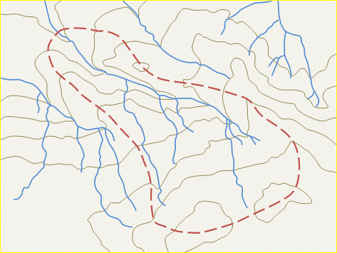
Figure 1.2 Example catchment boundary (![]() rivers,
rivers, ![]() catchment boundary,
catchment boundary, ![]() contour lines)
contour lines)
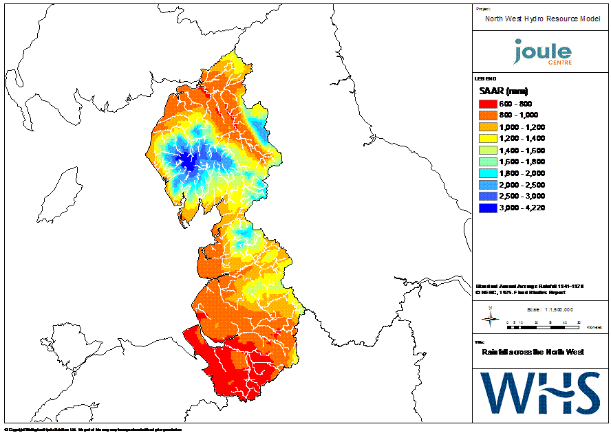
Figure 1.3 Rainfall across the North West (click on the image to enlarge)
Is there a gauging station nearby?
There is a network of almost 2000 gauging stations gauging river flows within the UK. Within England and Wales the gauging station network is run principally by the Environment Agency (EA). If there is a gauging station nearby you may be able to use this data to estimate the river flow in your catchment. Daily and monthly river flow data is available for over 1300 of these gauging stations from the UK National River Flow Archive (NRFA), and of these almost 150 of these are in the North West.
Using the NRFA website (www.ceh.ac.uk/data/nrfa) you can view summary statistics and descriptions of each of the gauging stations. You can view a map of the North West showing the locations of gauging stations (select the UK Gauging Station Network, then regional maps showing gauging station locations and clicking on the North West). From this map you can find the nearest gauging stations to your proposed schemes. This is an interactive map and you can click on the gauging station to view the stations summary statistics and descriptions.
Note that the gauging stations held by the NRFA are those with good quality long term records, but the EA do run further gauging stations. If you wish to gain information on a gauging station not held by the NRFA you can contact the EA (contact information is provided on the EA website, www.environment-agency.gov.uk).
Artificial influences
The majority of UK rivers are influenced to a greater or lesser degree by the activities of man; termed artificial influences. Common artificial influences include direct abstractions from surface waters, abstractions from ground water, discharge of effluents, impounding reservoirs, canals and inter-basin transfers.
In natural rivers, the magnitude of river flows are determined by climatic and runoff generation processes, amongst which effective rainfall, groundwater recharge and aquifer properties exert a dominant function. However, as a result of the development of rivers and catchments for a variety of purposes, including water supply and transport and dilution of effluent, few rivers now possess natural river flow regimes.
There are a number of ways to find out what is influencing your catchment. The best source of information is the EA Catchment Abstraction Management Strategies (CAMS). CAMS are six-year plans which record how the EA are going to manage water resources in your area. Your local CAMS document is an invaluable source of information, not only for finding out what already influences your catchment; but how the EA plans to manage water resources over the following six years. You can find out about the CAMS in your area from the EA website (www.environment-agency.gov.uk).
The NFRA website (www.ceh.ac.uk/data/nrfa) holds summaries of gauging stations which contain catchment descriptions. If there is a gauging station downstream, or upstream to some extent, of your proposed scheme you could use their descriptions of what is influencing the catchment. Select the gauging station and the Factor Affecting Runoff section will describe any major artificial influences on that catchment.
You could also use local knowledge and OS maps to find, for example, impounding reservoirs, sewage treatment works, factories, etc.